|
|
||
|
FYI: Yellowstone's Super Volcano - Discovery Channel Podcast .. Yellowstone is overdue
Posted by geologist Christopher C. Sanders on January 1, 2009. "I am advising all State officials around Yellowstone National Park for a potential State of Emergency. In the last week over 300 earthquakes have been observed by the USGS. We have a 3D view on the movement of magma rising underground. We have all of the pre warning signs of a major eruption from a super volcano. - I want everyone to leave Yellowstone National Park and for 200 miles around the volcano caldera."
Areas of
the United Stated
that once were covered by volcanic ash from
Yellowstone's giant eruptions
2 million and 630,000 years ago, compared with
ashfall from the 760,000-year-old
Long Valley caldera eruptions at Mammoth Lakes,
California, and the 1980
eruption of Mount St. Helens, Washington.
The State of
Montana Multi-Hazard
Mitigation Plan and Statewide Hazard Assessment
|
||
Links to
Explore:
Other Hot Spots: |
||
|
..
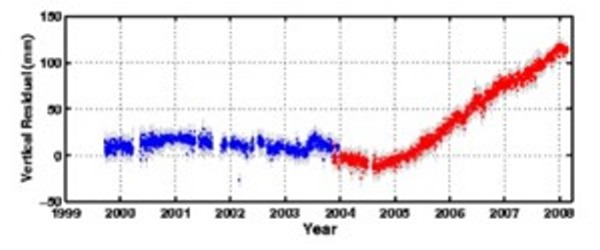
That such a heavenly place has the potential to unleash hell on earth is almost unbelievable. But its true, and it’s marching steadily toward eruption today and it has been since 2004. Although the current status of Yellowstone is green, the area is steadily swelling and has always shown signs of active volcanism, there may be no warning signs of imminent eruption. We may just go from green status to eruption. Yellowstone caldera measures roughly 1500 square miles. Compared to a normal volcanic caldera, Yellowstone is enormous. When it erupts it will launch an estimated 600 cubic miles of ash and debris into our atmosphere and completely obliterate anything in it’s path. When it does erupt, the volcano will unleash devastation the likes of which has not been seen in recorded history. The US, the breadbasket of the world will be instantly brought to its knees. Food production in the US will stop almost immediately, followed soon after by the rest of the world. The people of earth will begin to starve. Most of those in the US will be covered with a thick blanket of ash, making it difficult to breathe or find clean water. The airborne ash will blot out the sun around the world and start the global temperature plunge. Even though more CO2 will be released by Yellowstone than all of the combined burning of fuel since the modern age began, there will be no global warming, instead we will begin the march into the next ice age.
There have been some who have suggested that we try to prevent volcanoes by controlled eruptions. This approach is not only impractical, but unfortunately it’s impossible. It would definitely be nice if it were possible and it would prevent countless deaths that result from volcanic eruptions. So what is a person to do to prepare for this? There isn’t much you can do. If you decide you want to survive, it won’t be pleasant. The first thing you have to do is make sure you are at least 1000 miles away from the volcano when it erupts. If you are between a 1000 miles and 2500 miles, you’ll want a good respirator. No matter where you are, you’ll want clean water for at least 6 months and about 3 years of stored food. Your reward for your preparation will be a life of pure misery and horror as you watch the rest of the world slowly die from starvation and cold. SOURCE: The Looming Threat of Yellowstone - Vorchester.com |
||
|
..
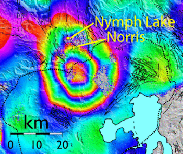
This image of ground deformation
was created using data from several satellite
passes from 1996 through
2000. The image shows 125 mm of uplift centred
within the northern end
of Yellowstone caldera (black dotted line),
about 10 km south of Norris.
Each full spectrum of colour (from red to
purple) represents about 28 mm
of uplift. The uplift is approximately 35 km x
40 km in size. - SOURCE:
ESA
ESA satellite reveals Yellowstone’s
deep secret
Satellite images acquired by ESA’s ERS-2 revealed the recently discovered changes in Yellowstone’s caldera are the result of molten rock movement 15 kilometres below the Earth’s surface, according to a recent study published in Nature. Using Synthetic Aperture Radar Interferometry, InSAR for short, Charles Wicks, Wayne Thatcher and other U.S. Geological Survey (USGS) scientists mapped the changes in the northern rim of the caldera, or crater, and discovered it had risen about 13 centimetres from 1997 to 2003. SOURCE: ESA |
||
|
January 1, 2009 ..
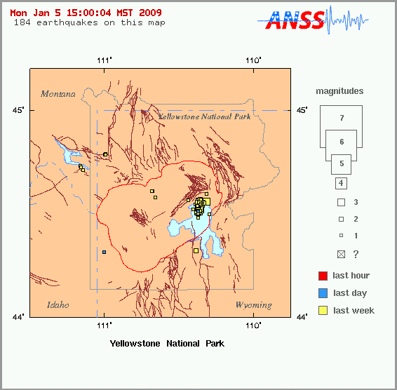
Yellowstone Supervolcano Getting Ready to Blow its Cork Updated 1-5-09
Over 500 Earthquakes at Yellowstone in the last week
"I am advising all State officials around Yellowstone National Park for a potential State of Emergency. In the last week over 252 earthquakes have been observed by the USGS. We have a 3D view on the movement of magma rising underground. We have all of the pre warning signs of a major eruption from a super volcano. - I want everyone to leave Yellowstone National Park and for 200 miles around the volcano caldera." |
||
|
The Yellowstone Caldera ..
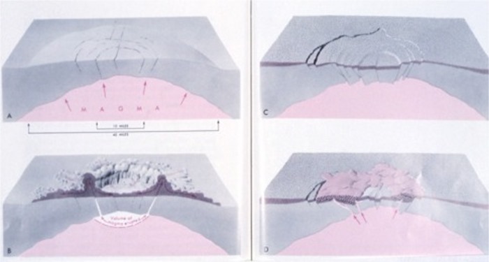
Courtesy of: http://www.news.wisc.edu/newsphotos/images/volano_lg.jpg The most recent caldera-forming eruption about 650,000 years ago produced a caldera 53 x 28 miles (85 x 45 kilometers) across in what is now Yellowstone National Park (Figure 2). During that eruption, ground-hugging flows of hot volcanic ash, pumice, and gases swept across an area of more than 3,000 square miles. When these enormous pyroclastic flows finally stopped, they solidified to form a layer of rock called the Lava Creek Tuff. Its volume was about 240 cubic miles (1,000 cubic kilometers), enough material to cover Wyoming with a layer 13 feet thick or the entire conterminous United States with a layer 5 inches thick. The Lava Creek Tuff has been exposed by erosion at Tuff Cliff, a popular Yellowstone attraction along the lower Gibbon River. The eruption also shot a column of volcanic ash and gases high into Earth's stratosphere. This volcanic cloud circled the globe many times and affected Earth's climate by reducing the intensity of solar radiation reaching the lower atmosphere and surface. Fine volcanic ash that fell downwind from the eruption site blanketed much of North America. This ash layer is still preserved in deposits as far away as Iowa, where it is a few inches thick, and the Gulf of Mexico, where it is recognizable in drill cores from the sea floor. Lava flows have since buried and
obscured most of the
caldera, but the underlying processes responsible
for Yellowstone's
|
||
| Alaska Quake
Changed Yellowstone
Geysers
Less than 18 hours after the Denali earthquake in Alaska, Smith and colleagues at the University of Utah Seismograph Stations reported the major jolt had triggered more than 200 small earthquakes in Yellowstone -- something widely reported by news media in the days following the quake. A powerful earthquake that rocked Alaska in 2002 not only triggered small earthquakes almost 2,000 miles away at Wyoming's Yellowstone National Park -- as was reported at the time -- but also changed the timing and behavior of some of Yellowstone's geysers and hot springs, a new study says. "We did not expect to see these prolonged changes in the hydrothermal system," says University of Utah seismologist Robert B. Smith, a co-author of the study in the June issue of the journal Geology. While other large quakes have been known to alter the activity of nearby geysers and hot springs, the Denali fault earthquake of Nov. 3, 2002, is the first known to have changed the behavior of such hydrothermal features at great distances, according to Smith and his colleagues. They say the magnitude-7.9 quake was one of the strongest of its type in North America in the past 150 years. Smith conducted the study with Stephan Husen, a University of Utah adjunct assistant professor of geophysics who works at the Swiss Federal Institute of Technology; Ralph Taylor, an engineer who designs geyser monitoring equipment at Yellowstone National Park; and Henry Heasler, Yellowstone National Park´s geologist. Yellowstone QuakesLess than 18 hours after the Denali earthquake in Alaska, Smith and colleagues at the University of Utah Seismograph Stations reported the major jolt had triggered more than 200 small earthquakes in Yellowstone -- something widely reported by news media in the days following the quake.Smith now says the triggered numbered more than 1,000 within a week of the Denali quake -- if the count includes tiny temblors that were not "located," meaning their epicenters and depths were not determined. He says the quakes ranged in magnitude from minus 0.5 to just under 3.0. (Tiny quakes have negative magnitudes because modern seismic equipment can detect quakes smaller than was possible when the logarithmic magnitude scales were devised.) Most of the triggered quakes were centered near geysers and hot springs. Strong Earthquakes as Seismic and Geothermal Triggers Scientists once believed that an earthquake at one location could not trigger earthquakes at distant sites. That belief was shattered in 1992 when the magnitude-7.3 Landers earthquake in California´s Mojave Desert triggered a swarm of quakes more than 800 miles away at Yellowstone, as well as other temblors near Mammoth Lakes, California, and Yucca Mountain, Nevada. The magnitude-7.5 Hebgen Lake, Montana, quake northwest of Yellowstone -- a 1959 disaster that killed 28 people -- triggered changes in Yellowstone´s geysers and hot springs, something not unexpected for a strong quake nearby. Smith believes the Denali fault ruptured in such a direction -- from northwest to southeast -- that the brunt of its energy and its powerful surface waves were aimed southeast toward Yellowstone. Geyser ActivityAs a result, the stresses rippling
through the ground
at Yellowstone were 200 to 300 times greater than if
the Denali quake´s
waves were aimed elsewhere, he says. As the Denali
quake´s surface
waves arrived at Yellowstone, changes in
hydrothermal activity first were
noted at the 100 Spring Plain hot spring system in
Norris Geyser Basin.
"Several small hot springs, not known to have
geysered before, suddenly
surged into a heavy boil with eruptions as high as 1
meter [about 39 inches],"
Smith and colleagues wrote in Geology. "The
temperature at one of these
springs increased rapidly from about 42 to 93to 199
degrees Fahrenheit]"
and became much less acidic than normal. "In the
same area, another hot
spring that was usually clear showed muddy, turbid
water." Meanwhile, some
geysers erupted more frequently than normal, while
others erupted less
frequently.
Yellowstone has more than 10,000 geysers, hot springs and fumaroles (steam vents), and scientists monitored how often 22 of the geysers erupted during the winter of 2002-2003. Eight of the 22 "displayed notable changes in their eruption intervals" after the Denali quake, 10 showed no significant changes and the other four were too erratic in the timing of their eruptions to determine if the quake changed them, the researchers wrote. Of the eight that changed: -- Geysers that erupted more frequently following the Denali quake included Daisy, Depression, Plume and Riverside geysers in Upper Geyser Basin, and Pink Geyser in Lower Geyser Basin. -- Geysers that erupted less frequently after the Denali quake included Castle and Plate geysers in Upper Geyser Basin and Lone Pine Geyser in West Thumb Geyser Basin. Most geysers returned to their normal timing days to months after the Denali quake. Oddly, geysers affected by earlier nearby earthquakes -- most notably Old Faithful and Grand Geyser in Upper Geyser Basin -- were not affected by the Denali earthquake. How the Denali Quake Sparked Yellowstone Activity Scientists do not know if the strong surface waves from the Denali quake independently triggered Yellowstone´s small quakes and changes in geyser activity. Smith suspects not. He believes the Denali quake´s waves affected the geysers by changing water pressure in underground conduits or "pipes" that feed the geysers. Such changes -- which in some cases would have made hot water "flash" explosively into steam -- would have altered the pressure on adjacent faults, triggering small earthquakes nearby. Ripple EffectWhy did some geysers erupt more
often and others less
often? The researchers believe that when the Denali
quake waves rippled
through Yellowstone, they jarred loose minerals that
had sealed some underground
hot water conduits. In some cases, that allowed
superheated, pressurized
water to flow more freely to make geysers erupt more
often. In other cases,
the rupturing of subterranean mineral seals enlarged
the size of the conduits
supplying geysers, reducing water pressure so those
geysers erupted less
often.
Smith speculates that yet other geysers remained unchanged because they did not have pent-up gas and water pressure and were not affected by the Denali quake´s surface waves. The Denali quake also generated noticeable water waves in Seattle´s Lake Union, Louisiana´s Lake Pontchartrain and in swimming pools on the East Coast. It also triggered small quakes in California´s Geysers geothermal area, which is north of San Francisco, and in eastern California´s Long Valley, which, like Yellowstone, is a caldera, or giant volcanic crater created by cataclysmic prehistoric volcanic eruptions. Hydrothermal Explosions?The Denali quake also triggered a
few small quakes in
Utah, and Smith says it is possible some of those
quakes occurred near
little-known hot springs along the Wasatch fault at
the base of the Wasatch
Range. Smith says the fact that the Denali quake
triggered geyser and hot
springs changes at Yellowstone raises an interesting
question: "Could large
earthquakes closer to Yellowstone trigger
hydrothermal explosions?" Such
steam-and-hot water explosions in prehistoric times
blasted out a hole
that now is Mary´s Bay on Yellowstone Lake.
One such explosion has occurred roughly every 1,000 years since the glaciers receded from Yellowstone roughly 14,000 years ago. Smith says there is no evidence prehistoric quakes triggered those blasts. And such explosions were not triggered by the magnitude-7.5 Hebgen Lake, Mont., quake in 1959 or the magnituk, Idaho, quake in 1983. Nevertheless, a big quake near Yellowstone with its surface waves aimed the right way conceivably might "cause large hydrothermal eruptions," says Smith. "I would hypothesize that is certainly possible." © 2004 Newswise i/a/w MarketWatch.com, Inc. All rights reserved. SOURCE: ALASKA EARTHQUAKE DANGERS |
||
| FAIR USE NOTICE: This page contains copyrighted material the use of which has not been specifically authorized by the copyright owner. Pegasus Research Consortium distributes this material without profit to those who have expressed a prior interest in receiving the included information for research and educational purposes. We believe this constitutes a fair use of any such copyrighted material as provided for in 17 U.S.C § 107. If you wish to use copyrighted material from this site for purposes of your own that go beyond fair use, you must obtain permission from the copyright owner. | ||
|
|


