| |
|
Mars ~ Meridiani
Planum Iron Prospects
Part
One
Parcel: MP-1000 Lots: MP-1000 to MP-1999 Planetary Location: Mars Feature Location: Meridiani Planum Location Available Lots History
|
||||||||||||||
|
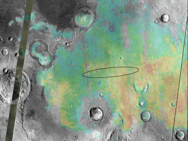
Fields of Hematite Opportunity Rover Landing Site
Image Courtesy of:
NASA/JPL/Arizona State University
This
mosaic of infrared images shows the abundance
and location of hematite at Opportunity's
landing site,
Meridiani Planum. On Earth, hematite is a mineral that typically forms in water. PIA05154:
Targeting a Hematite-rich Terrain
Original Caption Released with
Image:
This image shows the abundance
and location of the mineral grey hematite at the Mars
Exploration Rover Opportunity's landing site,
Meridiani Planum, Mars. Opportunity is targeted to
land somewhere inside the oval, approximately 71
kilometers (45 miles) long, on January 24, 2004
Pacific Standard Time. The background surface image of
Meridiani Planum is a mosaic of daytime infrared
images acquired by the thermal emission imaging system
instrument on NASA's Mars Odyssey Orbiter.
Superimposed on this image mosaic is a rainbow-colored
map showing the abundance and location of grey
hematite, as mapped by the thermal emission
spectrometer on NASA's Mars Global Surveyor orbiter.
Red and yellow indicates higher concentrations,
whereas green and blue areas denote lower levels. On
Earth, grey hematite is an iron oxide mineral that
typically forms in the presence of liquid water. The
rover Opportunity will study the martian terrain to
determine whether liquid water was present in the past
when rocks were being formed, and ultimately will
address whether that past environment was favorable
for life.
Image Credit: NASA/JPL/ASU
Image Addition Date: 2004-01-23 NASA source: PIA05154: Targeting a Hematite-rich Terrain |
||||||||||||||
|
Opportunity Rover Landing Site Meridiani Planum .
|
||||||||||||||
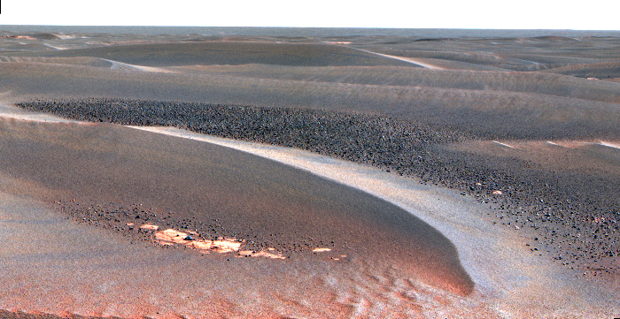
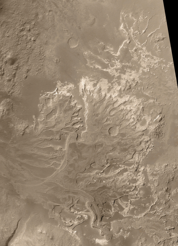 Distributory Fan Near Holden Crater PIA04869 Image Credit: NASA/JPL/Malin Space Science Systems The thermal emission imaging system (THEMIS) on Odyssey is both an infrared camera and a visible camera. It has captured telltale signs of past water on Mars. In four locations on Mars, THEMIS has detected high levels of hematite, a mineral that on Earth forms most often in the presence of liquid water. Discoveries by THEMIS and its predecessor instrument TES (thermal emission spectrometer) on the Mars Global Surveyor orbiter) led the 2003 Mars Exploration Rover mission team to choose Meridiani Planum as a landing site for its hematite content. Since landing, data from the Opportunity rover's science instruments, including the miniature thermal emission spectrometer (mini-TES) has confirmed THEMIS' results that the area was once covered in water. "The morphology and thermal properties of the Meridiani Planum region indicate that the hematite-bearing area was deposited in a standing body of water that extended over 100,000 square kilometers (300 miles by 100 miles or about the size of Oklahoma), with smaller bodies of water in nearby crater basins," said Christensen. THEMIS, along with Christensen's two other instruments at Mars (TES on Mars Global Surveyor and mini-TES on the rovers), has shown that liquid water could have been in a few areas within the equatorial region of Mars for thousands or tens of thousands of years. |
||||||||||||||
|
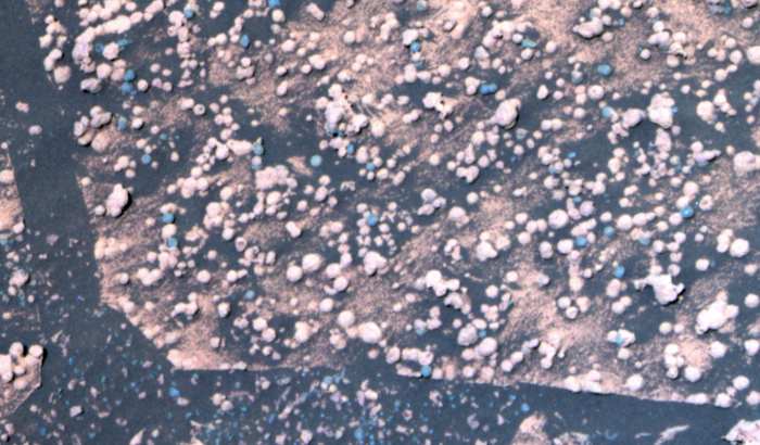
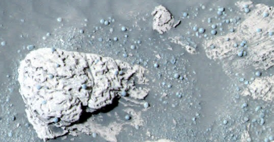
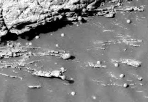
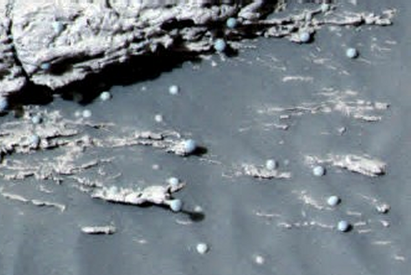
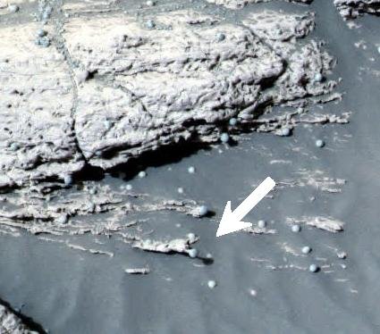
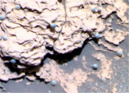
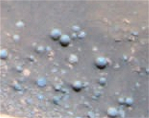
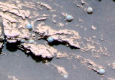
The Evidence for Water On Mars Part Two: The Martian "Blue Berries" ..
This microscopic image, taken at the outcrop region dubbed "Berry Bowl" near the Mars Exploration Rover Opportunity's landing site, shows the sphere-like grains or "blueberries" that fill Berry Bowl. The "triple berry" seen in the center of the microscopic image is intriguing to scientists because it reveals a clue about how the blueberries formed. Spheres formed from impacts or volcanoes do not tend to mold together like the spheres seen in the microscopic image. Spheres from impacts or craters are usually round or teardrop-shaped from flying in the air and freezing before hitting the ground. Any droplets of magma that combine with other droplets usually grow into a single mass in a spherical, dumbbell, or teardrop shape. In contrast, concretions could form this triple berry shape. Concretions are spherical mineral structures formed by groundwater percolating through porous rocks. On Earth, as concretions grow in close proximity to each other, their outer edges often intersect each other, giving an appearance like a triple soap bubble. Mineral in Mars 'Berries' Adds to Water Story - March 18, 2004 - Courtesy NASA A major ingredient in small mineral spheres analyzed by NASA's Mars Exploration Rover Opportunity furthers understanding of past water at Opportunity's landing site and points to a way of determining whether the vast plains surrounding the site also have a wet history. The spherules, fancifully called blueberries although they are only the size of BBs and more gray than blue, lie embedded in outcrop rocks and scattered over some areas of soil inside the small crater where Opportunity has been working since it landed nearly two months ago. Individual spherules are too small to analyze with the composition-reading tools on the rover. In the past week, those tools were used to examine a group of berries that had accumulated close together in a slight depression atop a rock called "Berry Bowl." The rover's Mössbauer spectrometer, which identifies iron-bearing minerals, found a big difference between the batch of spherules and a "berry-free" area of the underlying rock. "This is the fingerprint of hematite, so we conclude that the major iron-bearing mineral in the berries is hematite," said Daniel Rodionov, a rover science team collaborator from the University of Mainz, Germany. On Earth, hematite with the crystalline grain size indicated in the spherules usually forms in a wet environment. Scientists had previously deduced that the martian spherules are concretions that grew inside water-soaked deposits. Evidence such as interlocking spherules and random distribution within rocks weighs against alternate possibilities for their origin. Discovering hematite in the rocks strengthens this conclusion. It also adds information that the water in the rocks when the spherules were forming carried iron, said Dr. Andrew Knoll, a science team member from Harvard University, Cambridge, Mass. "The question is whether this will be part of a still larger story," Knoll said at a press briefing today at NASA's Jet Propulsion Laboratory, Pasadena, Calif. Spherules below the outcrop in the crater apparently weathered out of the outcrop, but Opportunity has also observed plentiful spherules and concentrations of hematite above the outcrop, perhaps weathered out of a higher layer of once-wet deposits. The surrounding plains bear exposed hematite identified from orbit in an area the size of Oklahoma -- the main reason this Meridiani Planum region of Mars was selected as Opportunity's landing site. "Perhaps the whole floor of Meridiani
Planum has a residual layer of blueberries," Knoll
suggested. "If that's true, one might guess that a
much larger volume of outcrop once existed and was
stripped away by erosion through time."
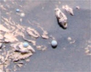
NASA's Mars Exploration Rover Opportunity is examining a type of rougher-textured, lighter-colored round pebbles that appear to be related to the smoother, darker spherules nicknamed "blueberries." The rover has found blueberries, which are actually gray, to be plentiful in Mars' Meridiani Planum region. This is a false-color composite image taken with the Mars Exploration Rover Opportunity's panoramic camera. It shows part of a rock called "Bylot" in the "Axel Heiberg" outcrop area low inside "Endurance Crater." A mixture of blueberries and the lighter-colored spherules, nicknamed "popcorn," lie on top of the rock. The image shows what appear to be, based on color, partially exposed blueberries inside popcorn spherules. Also visible are several irregular, gray fragments that may be pieces of blueberries scattered over the sand at the bottom of the image. |
||||||||||||||
|
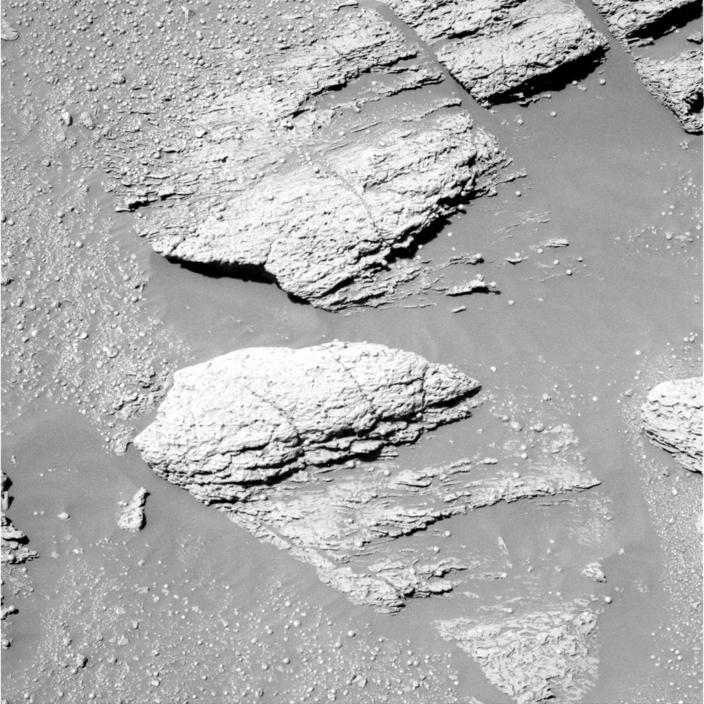
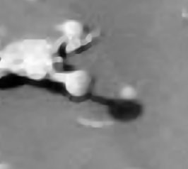
"Of
Blue Berries and Snails"
..
Above is the
original image from NASA. At first glance it looks
pretty much like all the other images of
"Blueberries" taken by the rover...
1P131479514EFF0534P2536L5M1.JPG
But looking a little
closer we find a really unusual anomaly...
NASA: SOL 037 Gallery |
||||||||||||||
| Part Two | ||||||||||||||
|
All material on these pages, unless otherwise noted, is © Pegasus Research Consortium 2001-2019 |
 Webpages © 2001-2019 Pegasus Research Consortium |