|
The Enigmas on Earth Impact Craters on Earth |
|||
|
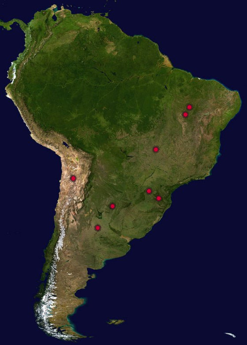
South America .
Earth Impact Database - The biggest collection of Earth Impact Craters by the University of New Brunswick, Canada Visit Also: |
|||
|
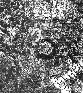
Brazil .
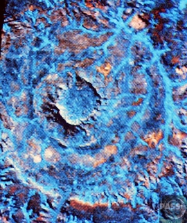
Several South
American impact structures have a tie-in with
Landsat. A crater in Brazil named Araguainha had
earlier been studied and classified as a dome. But
when visited by Dr. Robert S. Dietz - reknown for
his ability to find new craters - evidence (shatter
cones and breccias) was found that pointed towards
an impact origin. Samples were sent to Dr. Bevan M.
French, a colleague, to search for shock metamorphic
features. On the very same day he confirmed their
presence, the writer (NMS) phoned him to say that I
had found the following Landsat image, shown here as
a subscene: (above)
What we learned from the image was that the crater structure was about twice as wide (40 km; 25 miles) as field studies had suggested.The several tonal bands are due to differences in vegetation in this pampas grass country. |
|||
|
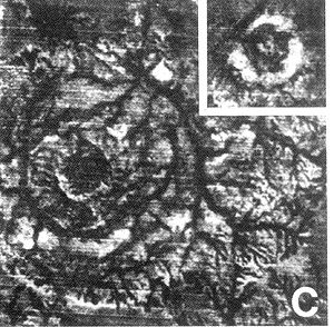
Brazil .
Riachao Ring, Brazil |
|||
|
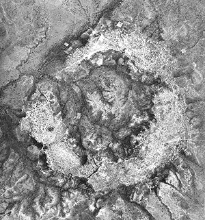
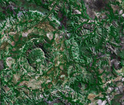
Brazil .
The hunt
pressed on to find other craters in vegetated
Brazil. Landsat was instrumental in finding this
12 km (8 mile) structure, Serra da Cangalha, with
its central depression.
|
|||
|
Brazil .
|
|||
|
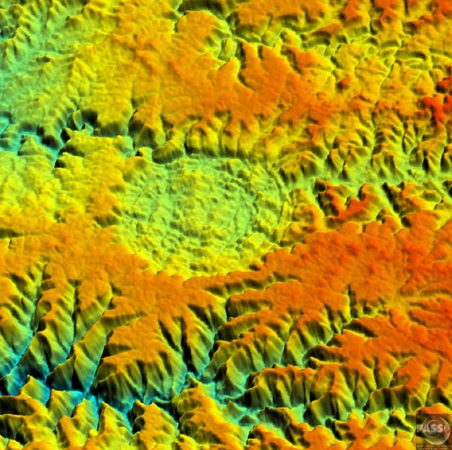
Bolivia .
An 8-kilometer
(5-mile) wide crater of possible impact origin is
shown in this view of an isolated part of the
Bolivian Amazon from the Shuttle Radar Topography
Mission. The circular feature at the center-left of
the image, known as the Iturralde Structure, is
possibly the Earth's most recent "big" impact event
recording collision with a meteor or comet that
might have occurred between 11,000 and 30,000 years
ago.
Although the structure was identified on satellite photographs in the mid-1980s, its location is so remote that it has only been visited by scientific investigators twice, most recently by a team from NASA's Goddard Space Flight Center in September 2002. Lying in an area of very low relief, the landform is a quasi-circular closed depression only about 20 meters (66 feet) in depth, with sharply defined sub-angular "rim" materials. It resembles a "cookie cutter" in that its appearance "cuts" the heavily vegetated soft-sediments and pampas of this part of Bolivia. The SRTM data have provided investigators with the first topographic map of the site and will allow studies of its three-dimensional structure crucial to determining whether it actually is of impact origin. Two visualization methods were combined to produce this image: shading and color coding of topographic height. The shade image was derived by computing topographic slope in the northwest-southeast direction. North-facing slopes appear bright and south-facing slopes appear dark. Color coding is directly related to topographic height, with brown and green at the lower elevations, rising through yellow and brown to white at the highest elevations. Elevation data used in this image was acquired by the Shuttle Radar Topography Mission aboard Space Shuttle Endeavour, launched on Feb. 11, 2000. The mission used the same radar instrument that comprised the Spaceborne Imaging Radar-C/X-Band Synthetic Aperture Radar (SIR-C/X-SAR) that flew twice on Endeavour in 1994. The Shuttle Radar Topography Mission was designed to collect 3-D measurements of Earth's surface. To collect the 3-D data, engineers added a 60-meter (approximately 200-foot) mast, installed additional C-band and X-band antennas, and improved tracking and navigation devices. The mission is a cooperative project between NASA, the National Imagery and Mapping Agency (NIMA) of the U.S. Department of Defense, and the German and Italian space agencies. It is managed by NASA's Jet Propulsion Laboratory, Pasadena, Calif., for NASA's Earth Science Enterprise, Washington, D.C. Size: 1 degree latitude by 1 degree
longitude (about 111 by 111 kilometers or 69 by 69
miles) |
|||
|
Chile .
|
|||
|
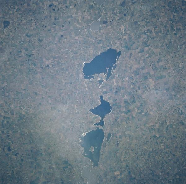
Argentina .
The northeast-southwest aligned string
of lakes spanning about 19 miles (30 kilometers)
is the result of about 10 oblong meteorite craters
ranging in size from a few kilometers to about 820
feet (250 meters) along their long axis. The shape
and alignment of the lakes suggests a low angle
impact. Small meteorites were found in a crater
confirming the lakes impact origin. The crater
lakes have been dated at less than 10000 years
old. From southwest to northeast, these lakes
include Laguna de la Sal, Laguna Venado, Laguna
Monte (lake with a large island near the center),
Laguna Cochico, and Laguna Alsina. These lakes are
located in west central Buenos Aires state. The
landscape surrounding the lakes is covered by
cultivated field patterns. - SOURCE
Google
Earth
|
|||
|
Argentina .
This crater is very hard to see, but it
has yielded many large meteorites like the one
above. El Chaco is one of five of the heaviest
meteorites in the world (37 tons). It was
unearthed in the 80's by W. Cassidy and his group.
There are twenty six documented craters in this region, the "Field of the Sky". Given the thickness of the virgin forest, there may be future discoveries of other similar craters. All the craters are numbered and some have own name. There are literally thousands of large specimens for sale around the world. This must have been a huge meteorite that broke apart and peppered the ground... Location: The first record of the Campo was in 1576. A Spanish governor learned of the iron from the Indians who reportedly believed that it had fallen from heaven. The governor sent an expedition under the command of one Captain de Miraval who brought back a few pieces of a huge iron mass he called Meson de Fierro (large table of iron). The location of the find was the Campo del Cielo (field of the sky or heaven), a fitting name for the location of a meteorite. Since the Indians believed that the irons fell from heaven the name may have come from the meteorites. The area is an open brush-covered plain that has little water and no other rocks--very good country in which to locate meteorites. The next record of Campo Del Cielo meteorites was about 200 years later in the late 1770s. The Spanish thought some pieces might be silver ore, but once they tried to process it, they found that it was only iron. A Spanish navy lieutenant excavated one specimen which he believed weighed 14 to 18 tons. This may have been the Meson de Fierro. He left he mass in place and it was not seen again--or was it? In the 1800s more smaller irons were found. A pair of flintlock pistols reportedly made of this material were given to President James Monroe. Later analyses showed that the iron was not meteoritic. In the 1900s. systematic exploration revealed many more large masses; however, the Meson de Fierro remained lost. In 1992, American meteorite dealer Robert Haag was arrested by Argentine authorities while transporting a 37 ton meteorite from the area. Haag had purchased the mass from a local person who claimed ownership. Unfortunately, the authorities disagrThe larger Campo del Cielo meteorites are found in and around a series of small craters in the southwestern part of the strewn field. The largest crater is 78 by 65 meters. A smaller one is 56 meters in diameter and 5 meters deep. All together, searchers have found at least 12 craters. The main part of the
crater-forming mass was found in each of these
craters. This is in contrast to Canyon Diablo and
Odessa where the main crater-forming mass is
believed to have vaporized or shattered on impact.
In this respect, the field is similar to
Sikhote-Alin. Many of the Campo meteorites are highly rusted and corroded by terrestrial chlorides, however some have significant areas of relatively fresh fusion crust. This too, is an indicator of a fall in the not-too-distant past. eed. Haag was released and the huge meteorite remains in Argentina. The larger Campo del Cielo meteorites are found in and around a series of small craters in the southwestern part of the strewn field. The largest crater is 78 by 65 meters. A smaller one is 56 meters in diameter and 5 meters deep. All together, searchers have found at least 12 craters. The main part of the
crater-forming mass was found in each of these
craters. This is in contrast to Canyon Diablo and
Odessa where the main crater-forming mass is
believed to have vaporized or shattered on impact.
In this respect, the field is similar to
Sikhote-Alin. Many of the Campo meteorites are highly rusted and corroded by terrestrial chlorides, however some have significant areas of relatively fresh fusion crust. This too, is an indicator of a fall in the not-too-distant past. |
|||
| FAIR USE NOTICE: This page contains copyrighted material the use of which has not been specifically authorized by the copyright owner. Pegasus Research Consortium distributes this material without profit to those who have expressed a prior interest in receiving the included information for research and educational purposes. We believe this constitutes a fair use of any such copyrighted material as provided for in 17 U.S.C § 107. If you wish to use copyrighted material from this site for purposes of your own that go beyond fair use, you must obtain permission from the copyright owner. | |||
|
|