|
Subduction Zones |
|||||||
|
..
.
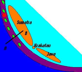
.. and is consumed by the earth's mantle. Illustration from USGS Visual Glossary Example from Indonesian Islands The Boxing Day Tsunami 2004 and the Krokatau tsunami of 1883 both started at this subduction zone.
This is an extremely simplified diagram, not to scale and out of any proportions. The eartquake that triggered the boxing day tsunami is marked in red on the map, and the volcanic islands that constituted only one island, Krakatau, before 416 A.D.? when a caldera collapse destroyed the volcano, is shown (as one island) between Sumatra and Java. Sediment scraped off the Australian Plate during its subduction under the Asian plate forms an accretionary prism or wedge. The tops of this "mountain range" are above sea level and show up as islands (I have not placed any of these islands - like the Mentawai Islands mentioned below - at their exact locations, I just put them there to show the principle). The coldness of the subducting plate permits brittle failure, and thereby earthquakes, down to as much as 700 km along the so called Benioff zone. The Benioff Zone is defined as the active seismic zone in a subduction zone. Water escaping from the descending plate is probably the primary cause of volcanic activity at subduction zones, but whatever the reason melting of rocks take place and magma rises to form a magmatic or volcanic arc. Volcanoes at subduction zones can be extremely explosive like Krakatau in Indonesia and like Mount St. Helens (in the American Cascade Range). Five years ago Ken Wohletz argued that the Dark Ages may have been triggered by volcano-related climate changes in the 6th Century (in the vicinity of 535 A.D.?), and the Krakatau volcano may have been the culprit. See http://www.ees1.lanl.gov/Wohletz/Krakatau.htm Source: http://whatonearth.olehnielsen.dk/Tectonics.asp
The subduction zone (here shown as a dark blue line) continues to make half a circle around the centre of the Banda Sea, where the plate tectonic situation is much more complex. In short however the Banda Arc is bounded by an inner volcanic arc and an accretionary outer arc of which Timor is the largest island. Olelog on Banda Sea earthquake (on 27 January 2006) at http://my.opera.com/nielsol/blog/show.dml/125760
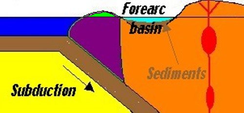
As the subducting plate slides beneath the upper plate, stress begins to build where the plates meet and the upper plate can deform to create a large structure called a forearc basin. With time this basin, a sort of a bowl-shaped depression, fills with sediment. It appears that the most severe subduction zone earthquakes occur in areas where such sediment-filled basins are found (like the earthquake that triggered the Boxing Day Tsunami in 2004). |
|||||||
|
..
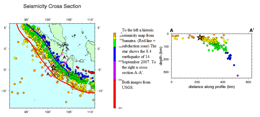
In a subduction zone the earthquake foci normally plot along a dipping plane at an angle of 33 to 60 degrees and this plane is called a Benioff zone. The zone is named after Hugo Benioff, a US seismologist who first described this feature. The Benioff zone extends to a depth of about 700 km. Example from Sumatra:
Double Benioff
Zones Subduction zones occur where one tectonic plate collides with another and descends into the mantle. Most of the world’s disastrous earthquakes and volcanoes take place at subduction zones. In a subduction zone the earthquake foci normally plot along a dipping plane at an angle of 33 to 60 degrees and this plane is called a Benioff zone. The reason for the earthquakes seems simple enough. When the descending slab on its way downwards rub its neck against the plate on top of it, it must lead to trembles. The high pressure existing below a depth of about 70 km should, however, normally prohibit the release of strain that leads to earthquakes, but earthquakes at the Benioff zone can be as deep as about 700 km. The mechanisms for deep earthquakes is therefore under ongoing debate. Brittle failure (sudden slip along a fault) is the cause for most of the earthquakes in Earth’s crust (<50 km depth). However, due to the high temperature and pressure at the depth level of Benioff zone earthquakes the rocks will instead undergo ductile deformation, which inhibits earthquake faulting. Benioff zones were originally believed to be singe layers of earthquake activity. The recent huge increase in high resolution, more accurate, earthquake data collected and high tech data processing tools has given us a more complex picture of Benioff zones, and shown that some subduction zones have two parallel layers of earthquake activity (and a few maybe even three). In a report titled "Global Prevalence of Double Benioff Zones” in the journal Science of 8 June 2007 Brudzinski et al. concludes that double Benioff zones are the rule rather than the exception in the depth range between 50 and 300 km. It seems to take time to develop a double Benioff zone. The double Benioff zone separation reveals a significant increase with plate age, from ~8 km for a ~12 million years old slab up to ~30 km for a ~160 million years old slab. A commonly accepted model for deep earthquakes is dehydration embrittlement, in which fluids released by hydrous minerals of the crust and mantle of the slab can lead to high pore pressures, reduce the effective stress on pre-existing faults, and hence promote the occurrence of earthquakes. A variety of hydrous minerals have been suggested as contributors. The primary candidate for the upper Benioff zone is metamorphosed basalt near the top of the plate. According to Brudzinski et al. petrologic candidates that might explain the lower Benioff zone as the result of dehydration include antigorite and chlorite in hydrous peridotite. The chlorite dehydration reaction occurs at higher temperatures of 700 to 800°C (deeper within the plate). They find that antigorite dehydration is consistent with all the observed double Benioff zone separations, whereas chlorite dehydration can explain only a few cases. Source: http://whatonearth.olehnielsen.dk/Tectonics.asp Related Links: |
|||||||
|
.. Uploaded
on Jul 31, 2009
Animation of seismic cycle, showing subduction of oceanic tectonic plate and resulting deformation of upper continental tectonic plate. |
|||||||
|
..
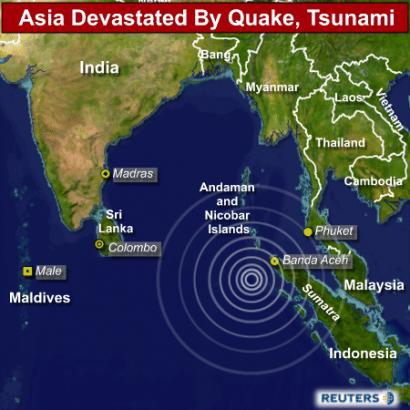
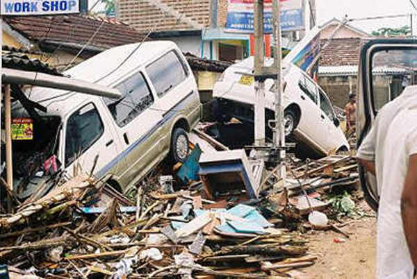
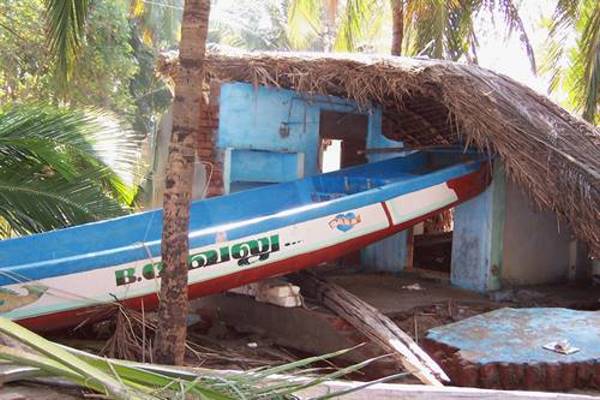
The 2004 Indian Ocean earthquake was an undersea megathrust earthquake that occurred at 00:58:53 UTC on Sunday, December 26, 2004, with an epicentre off the west coast of Sumatra, Indonesia. The quake itself is known by the scientific community as the Sumatra-Andaman earthquake. The resulting tsunami is given various names, including the 2004 Indian Ocean tsunami, Asian Tsunami, Indonesian Tsunami, and Boxing Day Tsunami. The earthquake was caused by subduction and triggered a series of devastating tsunamis along the coasts of most landmasses bordering the Indian Ocean, killing over 230,000 people in fourteen countries, and inundating coastal communities with waves up to 30 meters (100 feet) high. It was one of the deadliest natural disasters in recorded history. Indonesia was the hardest hit, followed by Sri Lanka, India, and Thailand. With a magnitude of between 9.1 and 9.3, it is the third largest earthquake ever recorded on a seismograph. This earthquake had the longest duration of faulting ever observed, between 8.3 and 10 minutes. It caused the entire planet to vibrate as much as 1 cm (0.4 inches) and triggered other earthquakes as far away as Alaska. Its hypocenter was between Simeulue and mainland Indonesia. The plight of the many affected people and countries prompted a worldwide humanitarian response. In all, the worldwide community donated more than $14 billion (2004 U.S. dollars) in humanitarian aid.
radiated from the entire length of the 1,600 km (994 mi) rupture. Related Links:
|
|||||||
|
Tsunami
Caught On Camera
Published on Feb 4, 2013 NO PARTS copyright was not intended Commercial Interruption brought to you by Channel 4 news: 24:19 WARNING: This movie is very intense and graphic, It may make you cry. Viewer Discretion is Advised. It is rated TV-MA |
|||||||
| From the unbelievable chaos of the Tsunami
disaster comes an incredible tale from Jim France of
the Pavilion Hotel Group in Bangkok.
At a resort on Phuket, one of the most popular attractions is (was) elephant rides. As many as eight people on one elephant, first into the surrounding forest, then down to the beach, to lunch at a fresh water lagoon, then back to the hotel. The elephants (nine) were kept chained to iin-ground posts, not because they needed to be, but because it made the mothers feel better because their children seemed safe from a tromping when feeding the beasts. About twenty minutes before the first wave hit, the elephants became extremely agitated and unruly. Four had just returned from a trip and their handlers had not yet chained them. They helped the other five tear free from their chains. They all then climbed a hill and started bellowing. Many people followed them up the hill. Then the waves hit. After the waves subsided, the elephants charged down from the hill, and started picking up children with their trunks and running them back up the hill; when all the children were taken care of, they started helping the adults. They rescued forty-two people. Then, they returned to the beach and carried up four dead bodies, one of a child. Not until the task was done would they allow
their handlers to mount them. Then with
handlers atop, they began moving wreckage |
|||||||
..
Immediately following the 2004 Tsunami, the world was so rocked with the staggering death toll of nearly 240,000 individuals that it is often forgotten that many of the more rural and traditional citizens were able to survive through an indigenous understanding of the signs of an incoming tsunami. For example, scientists in the area initially were convinced that the aboriginal population of the Andaman Islands would be significantly ravaged by the tsunami, however, all but one of the tribes in the islands (oddly enough, the one that had largely converted to Christianity and thus, a change of lifestyle,) suffered only minor casualties. When questioned, the tribesmen explained to the scientists that the land and ocean often fought over boundaries and when the earth shook they knew that the sea would soon enter the land until the two could realign their borders. Because of this, the villagers fled to the hills and suffered little or no casualties. Additionally of note is the story of Tilly Smith, a 10-year-old British student vacationing on Mikakhao Beach in Thailand. Tilly, had recently studied tsunamis in school and immediately recognized the frothing bubbles and receding ocean as a harbinger of a tsunami. Along with her parents, they warned the beach and it was entirely evacuated safely. - Source: Worldprehistory.blogspot.com
..
The energy released by the 2004 Indian
Ocean earthquake and tsunami was estimated at
26.3 megatons of TNT, equivalent to over 1.502
times that of the Hiroshima atomic bomb. My
thoughts and deepest sympathy are with the
relatives of the 220.000 people who died four
years ago, in this very day.(This was taken
somewhere on the portuguese coast)
..
|
|||||||
|
Posted on Monday, 14 November 2005, 20:29:44 Krakatau tsunami One of the greatest natural disasters in modern history was the eruption of the Krakatau (or Kakatoa) volcano in 1883. The following tsunami killed 36,000 people. If a similar explosion of the same power happened today, the tsunami might kill about one million people. Anak Krakatau, Krakatau's child, was
born about 70 years ago and now grows six meters a
year. If its growth rate doesn't decrease, the
world will face another great tragedy, says
Indonesian volcanologist Supriyatman Sutavijaya
from the Indonesian University of Volcanology and
Geology. If the processes in the magma chamber
maintains the current speed, another explosion
will happen in 140 years. |
|||||||
| FAIR USE NOTICE: This page contains copyrighted material the use of which has not been specifically authorized by the copyright owner. Pegasus Research Consortium distributes this material without profit to those who have expressed a prior interest in receiving the included information for research and educational purposes. We believe this constitutes a fair use of any such copyrighted material as provided for in 17 U.S.C § 107. If you wish to use copyrighted material from this site for purposes of your own that go beyond fair use, you must obtain permission from the copyright owner. | |||||||
|
|


