Source: nawcwpns.navy.mil/
|
|
||
|
Vietnam 1967-1972 ..
Geophysical Warfare
-- "Rainmakers." During the Vietnam Conflict, our warfighters needed a
way to interdict enemy traffic on the Ho Chi Minh Trail. "Project Popeye"
helped answer the call. China Lake adapted its cloud seeding technologies
to enhance rainfall thereby significantly deterring enemy activity on the
trail. This highly successful China Lake technology was also used in hurricane
abatement, fog control, and drought relief.
|
||
|
Vietnam 1967-1972 ..
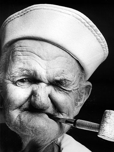
'Popeye' was discovered in a nursing home diagnosed with Alzheimer's. Every morning he would dress the same and always request spinach with his meals.In his own mind and in my camera lens, he was 'POPEYE'. Operation PopeyeOperation Popeye (Project
Popeye/Motorpool/Intermediary-Compatriot) was a US military cloud
seeding operation (running from March 20, 1967 until July 5, 1972) during
the Vietnam war to extend the monsoon season over Laos, specifically areas
of the Ho Chi Minh Trail. The operation seeded clouds with silver iodide,
resulting in the targeted areas seeing an extension of the monsoon period
an average of 30 to 45 days. As the continuous rainfall slowed down the
truck traffic, it was considered relatively successful.
The 54th Weather Reconnaissance Squadron carried out the operation to "make
mud, not war."
Project Popeye (1966)Project Popeye was an experiment in increased rainfall
through cloud seeding jointly approved by the U.S. Department of State
and U.S. Department of Defense. The technical aspects of the experiment
were verified by Dr. Donald F. Hornig, Special Assistant to the President
of the United States for Science and Technology. The government of Laos
was not informed of the project, its methods or its goals.
Robert S. McNamara, U.S. Secretary of Defense, was aware that there might be objections raised by the international scientific community but said in a memo to the president that such objections had not in the past been a basis for prevention of military activities considered to be in the interests of U.S. national security. During October 1966, Project Popeye was tested in a strip of the Laos panhandle east of the Bolovens Plateau in the Se Kong River valley. The test was conducted by personnel from the Naval Ordnance Test Station located at China Lake California. Fifty cloud seeding experiments were conducted with the result that 82% of the clouds produced rain within a brief period after having been seeded. It was claimed that one of the clouds drifted across the Vietnam border and dropped nine inches of rain on a US special forces camp over a four hour period. After the successful completion of the test phase, Project Popeye transitioned from an experiment to an operational program of the U.S. Defense department. The Operation's ObjectivesOperation Popeye goal was to increase rainfall in carefully selected areas to deny the Vietnamese enemy, namely military supply trucks, the use of roads by:
Operation PopeyeStarting on March 20, 1967 and continuing through every
rainy season (March to November) in Southeast Asia until 1972, operational
cloud seeding missions were flown. Three C-130 aircraft and two F4-C aircraft
based at Udorn Royal Thai Air Force Base Thailand flew two sorties per
day. The aircraft were officially on weather reconnaiseance missions and
the aircraft crews as part of their normal duty generated weather report
information. The crews, all from the 54th Weather Reconnaissance Squadron,
were rotated into the operation on a regular basis from Guam. Inside the
squadron, the rainmaking operations were code-named "Motorpool".
The initial area of operations was the eastern half of the Laotian panhandle. On 11 July 1967, the operational area was increased northward to around the area of the 20th parallel and included portions of far western North Vietnam. In September 1967, The A Shau Valley in South Vietnam was added to the operational area. Operations over North Vietnam were eliminated on April 1, 1968 concurrent with conventional bombing restrictions being put into effect. The southern region of North Vietnam was added to the operational area on September 25, 1968 and then removed on November 1st of that year concurrent with a halt to conventional bombing of North Vietnam. In 1972, most of northeastern Cambodia was added to the operational area, All rainmaking operations ceased on July 5, 1972. Reporter Jack Anderson published a story in March 1971
concerning Operation Popeye (though in his column it was called Intermediary-Compatriot).
The name Operation Popeye (Pop Eye) entered the public space through a
brief mention in the Pentagon Papers
and a July 3 1972 article in the New York Times [5].
Operations in Laos ceased two days after the publication of the Times article.
The press stories led to demands from members of the U.S. Congress, led by Senator Claiborne Pell, for more information. U.S. House and Senate resolutions in favor of banning environmental warfare were passed as Senate Resolution 71 on July 11, 1973, H.R. 116 of 1974, H.R. 329 of 1974 and H.R. 28 of 1975. Current Law and Operation Popeye Weather modification procedures when performed to achieve a military end now fall under the provenance of the Convention on the Prohibition of Military or Any Other Hostile Use of Environmental Modification Techniques.
|
||
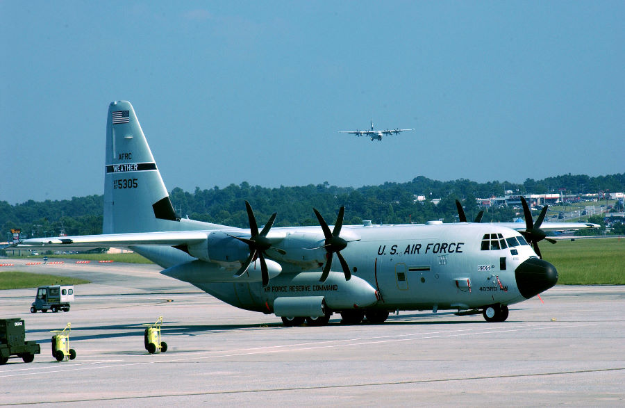
Hurricane Hunters rebound, gear up for next storm Photo of the WC-130 Hercules airplane operated by the Air Force Reserve Command The WC-130 Hercules is a high-wing, medium-range aircraft used in weather reconnaissance missions. This plane is a C-130 transport configured with palletized weather instrumentation for penetration of tropical disturbances and storms, hurricanes and winter storms to obtain data on movement, size and intensity. The WC-130 is the weather data collection platform for the 53rd Weather Reconnaissance Squadron. Operational History The WC-130B model was operational with the former Military Airlift Command's Air Weather Service from 1962 to 1979, the E model from 1965 to 1993, followed by the H model from 1973 to 2005 with the 53rd, 54th, 55th and 56th Weather Reconnaissance Squadrons under the 9th Weather Reconnaissance Wing. Three WC-130A models were operational in South East Asia from 1967 to 1970 with the 54th Weather Reconnaissance Squadron. Only the J model, introduced in 1999, is currently in operation as of 2006 with the 53rd Weather Reconnaissance Squadron, now part of the 403rd Wing of the Air Force Reserve Command. The WC-130J and NOAA's WP-3D Orion provide vital tropical cyclone forecasting information. They penetrate tropical cyclones and hurricanes at altitudes ranging from 500 to 10,000 feet (150 to 3,000 m) above the ocean surface depending upon the intensity of the storm. The aircraft's most important function is to collect high-density, high-accuracy weather data from within the storm's environment. This includes penetration of the center or hurricane eye of the storm. This vital information is instantly relayed by satellite to the National Hurricane Center to aid in the accurate forecasting of hurricane movement and intensity.
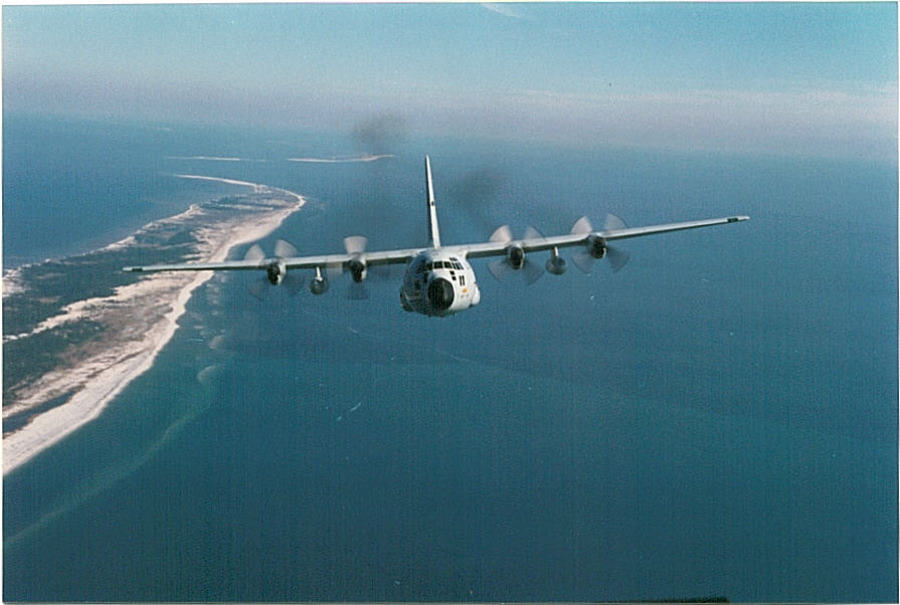
WC-130H Hercules in flight The aircraft is capable of staying aloft almost 18 hours at an optimum cruise speed of more than 300 miles per hour. An average weather reconnaissance mission lasts 11 hours and covers almost 3,500 miles. The crew collects and reports weather data as often as every minute. The WC-130J carries a minimal crew of five: pilot, co-pilot, navigator, aerial reconnaissance weather officer and weather reconnaissance loadmaster. The crew and the aircraft are assigned to the 53rd WRS , an Air Force Reserve Command unit assigned to the 403rd Wing at Keesler AFB, MS. The 53rd WRS, known as the Hurricane Hunters, is responsible for the reconnaissance mission in the Atlantic Ocean, Caribbean Sea, Gulf of Mexico, and Eastern and Central Pacific Ocean areas. From the front of the cargo compartment, the Aerial Reconnaissance Weather Officer operates the computerized weather reconnaissance equipment and acts as flight director in the storm environment. The weather officer also evaluates other meteorological conditions such as turbulence, icing, visibility, cloud types and amounts, and ocean surface winds. The ARWO uses the equipment to determine the storm's center and analyze atmospheric conditions such as pressure, temperature, dew point and wind speed. A critical piece of weather equipment on board the WC-130J is the dropsonde system. The GPS Dropsonde Windfinding System is a cylindrically-shaped instrument about 16 inches long and 3.5 inches in diameter and weighs approximately 2.5 pounds. The dropsonde is equipped with a high frequency radio and other sensing devices and is released from the aircraft about every 400 miles over water. As the instrument descends to the sea surface, it measures and relays to the aircraft a vertical atmospheric profile of the temperature, humidity and barometric pressure and wind data. The dropsonde is slowed and stabilized by a small parachute. The Dropsonde System Operator receives, analyzes and encodes the data for transmission by satellite. Beginning in May 2007, the WC-130J will be equipped with the Stepped-Frequency Microwave Radiometer, which continuously measures the surface winds and rainfall rates below the aircraft. The WC-130J provides data vital to tropical cyclone forecasting. The WC-130J usually penetrates hurricanes at an altitude of approximately 10,000 feet to collect meteorological data in the vortex, or eye, of the storm. The aircraft normally flies a radius of about 100 miles from the vortex to collect detailed data about the structure of the tropical cyclone. The information collected makes possible advance warning of hurricanes and increases the accuracy of hurricane predictions and warnings by as much as 30 percent. Collected data are relayed directly to the National Hurricane Center, in Miami, Fla., a Department of Commerce weather agency that tracks hurricanes and provides warning service in the Atlantic area. Specifications General characteristics
|
||
| FAIR USE NOTICE: This page contains copyrighted material the use of which has not been specifically authorized by the copyright owner. Pegasus Research Consortium distributes this material without profit to those who have expressed a prior interest in receiving the included information for research and educational purposes. We believe this constitutes a fair use of any such copyrighted material as provided for in 17 U.S.C § 107. If you wish to use copyrighted material from this site for purposes of your own that go beyond fair use, you must obtain permission from the copyright owner. | ||
|
|


