|
|
||||||||
|
Overridden by NSA Magnetic Anomaly, Lake Vostok ..
Magnetic Anomaly, Lake Vostok
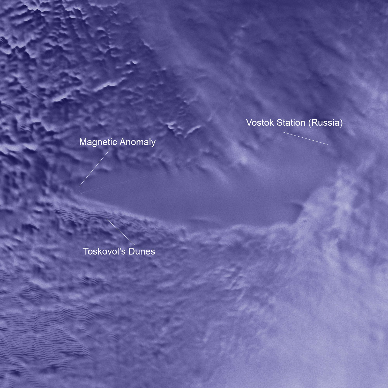
http://www.polar.org/AntSun/2001_0204/index.html - (See Note) I quote from there :- "The evidence is a huge magnetic anomaly on the east coast of the lake's shoreline. As the first SOAR flight crossed over to the lake's east side, the magnetometer dial swung suddenly. The readings changed almost 1,000 nanotesla from the normal 60,000 nanoteslas around Vostok. A tesla is the standard measure of magnetism. Studinger typically finds anomalies of 500-to-600 nanotesla in places where volcanic material has poured out of the groundI deal with interpreteting aeromagnetic imagery daily in my mineral exploration work here in OZ. The huge size and intensity of the above mentioned magnetic anomaly strongly suggests a very large ultrabasic complex is present below this section of lake Vostok in the continental crustal rock surface ie at the old land surface -pre ice level. This would fit with the apparently tensional pull-apart rifted tectonic style of the lake geo-environment and would probably represent a major mantle derrived plume of ultrabasic intrusives along the lines of Prof Careys Expanding Earth diapirs - this fits the stretched crust model noted by Studinger above. As such it would also fit Prof. Gold's hypothesis that there is a substantial - possibly world climate dangerous amount if released - volume of methane (as hydrate at the expected temperatures ?) plus oil and other exotic gas (He, X, etc) component to the hot water lake - sourced from the Mantle-Core along the upwelling structural plumbing. The reported "ice boils" could easily be composed of gaseous plumes frozen into the ice - arrested as it were in their upwards progress - initially as hotwater gas mixtures but cooled by the surrounding ice until their water content froze and they could no longer melt (ie. rise) through the ice above them. As such these ice boils could represent fascinating analogies with granite intrusive plumes in mountain belts - both "boils" rise due to their heat melting above rock (ice) layers whiulst their lower density relative to enclosing rocks causes a gravity gradient and drives their upward motion until they crystalise (freeze). The ice "dunes" look like flat ice folded under stress - also analagous to folds in sediments in mountain belts around the planet - possibly due to gravity sliding away from the upwelling diapir of lake vostok ? Re the two women sking across the ice shelf scenario - they were interviewed on Australian ABC news a few days ago after being dropped off at an Australian Antarctic base by the US "rescue" team. I saw this news segment. They stated they personally requested airlift as their progress had been slower than anticipated and they were in danger from rapidly advancing winter storms. Once these hit you are isolated from air or ground rescue for months. They appeared quite relaxed but wistful about their need for rescue - did not appear "got at" but who knows? I have previously seen the most outrageous lies propagated by our ABC TV News over the AUM sect and Banjawarn Station Sarin Nerve gas stories. My personal field research interviewed the Banjawarn Station people (indigenous and white) and uncovered a huge series of lies aired knowingly by the ABC - so who knows on this Antarctic scenario? Also just read your Atlantis TV story URL's - are they describing real events - or just make believe - if real then it certainly looks like a major cover up is in progress on a recovery mission of some sort down there at "Ice Station Zebra" ! The mind boggles as to what is really going on - perhaps the lid almost got blown on early Mars Lander tests that actuallly got up there in the 1960's - a la Alternative 3! Looking forward to more info on your site as this one unfolds ................... Regards, Harry
|
||||||||
| International
Space Mapping of Lake Vostok Overridden by NSA
Images:
|
||||||||
| ADDITIONAL CORRESPONDENCES BELOW:
SOURCE:
cyberspaceorbit.com/vostkharx.htm
Dear Duncan and David Kingston, A friend has found NASA Press Release 01-24 from Feb 21-2001 which I copy; Dear Duncan, and David Kingston, Just another point about the "Space Mapping Mission of Antarctica Aborted Due to NSA Over-Ride" story. The letter states that "The linked photo at the end was released by NASA in Jan 2001 seemingly by mistake. It is no longer available from the official archive" !!! Yet take a look at this reproduction of an official NASA web site of the EXACT SAME radarsat image and the attached section (58.1Kb jpg) image I just cut out today (1-03-2001 - 2.00pm) from the Vostock High Resolution Bird's Eye View Tif (3.8Mb) that I downloaded from http://svs.gsfc.nasa.gov/imagewall/antarctica/vostok.html Further a close inspection reveals a road running diagonally from SW to NE across the lake (smoothed out on Anons original jpg - but just visible there also) that originates at a camp site in the SW corner of the lake with a NNW trending "airstrip" ??? The road continues NE off of the field of the image. I suspect that the image provided by anon has incorrectly labelled the SW airstrip and camp as the "Magnetic Anomaly" and has most certainly placed Vostok Station (Russia) with an arrow pointing where there is nothing but Ice. Incidentally elsewhere in NASA literature Vostok Station is said to be situated at the southern end of the lake and if NASA followed convention with it's image orientation then Vostok Station is where the airstrip-camp site show in the SW part of the lake. In otherwords who ever wrote up the story line did NOT know much about the correct location of things around lake vostok. Also the Russians have drilled down 3600 metres since the lake discovery in the 1970's (to some 400 metres ??? above the liquid lake surface) with preserved ice cores being sent to Montana State University a few years ago. These have been analysed and they found various gases locked up in the ice (including methane). Due to the above errors about the so called missing (removed) image and the location of sites around Lake Vostok I am inclined to place a very large red flag against this anon post. Do you have any corroborative data for the original premise of NSA Over-Ride and the removal from stage of Debra Shingteller.................. Regards, Harry Mason
SPACE MAPPING MISSION OF ANTARCTICA ABORTED DUE TO NSA OVER-RIDE" . When the actual title of NASA Release 01-24 is (as seen below) "SPACE MAPPING MISSION CATCHES ANTARCTICA IN MOTION".............................. Personally I would like to see some more backing for the original press conference - but I still feel the letter has a ring of truth about it ???? Have you got any more info ??? Regards, Harry
-----Original Message----- From: owner-press-release@lists.hq.nasa.gov [mailto:owner-press-release@lists.hq.nasa.gov]On Behalf Of NASANews@hq.nasa.gov Sent: Thursday, 22 February 2001 0:10 To: undisclosed-recipients:; Subject: SPACE MAPPING MISSION CATCHES ANTARCTICA IN MOTION David E. Steitz
Rosemary Sullivant
RELEASE: 01-24 SPACE MAPPING MISSION CATCHES ANTARCTICA IN MOTION Antarctica may appear to be
a land frozen in time, but it certainly is not still. Glaciers plow down
the continent's
A joint NASA and Canadian Space Agency mission now provides a more comprehensive view of how the Antarctic ice sheet moves and changes and may help answer some fundamental questions about this mysterious place at the end of the world, including whether the ice sheet is advancing or retreating. The initial mapping campaign, the 1997 Antarctic Mapping Mission, resulted in the first high-resolution radar satellite map of the continent. The second phase, the Modified Antarctic Mapping Mission, completed last November, once again charted Antarctica with space-based imaging radar. This second mission gives scientists a way to see how the continent has changed over the past three years as well as a wealth of new information on the movement of the most active region, the outer half of the ice sheet. "The 1997 map became a benchmark for studying changes on the continent and also revealed fascinating features, including enormous ice streams in East Antarctica, that we had never seen before. We expect to find even more surprises from this second, even more detailed map that will help us unravel some of the mysteries behind how our global environment behaves," said Dr. Ghassem Asrar, Associate Administrator for NASA's Office of Earth Sciences, Washington, DC. For the new mission, the Canadian Space Agency's RADARSAT-1 satellite trained its imaging radar on the outer half of the continent twice during each of three consecutive 24-day periods, ending last Nov. 14. "The mission was a challenge for us because we had to accurately navigate the satellite to within a few hundred meters of its nominal track on each orbit," said Rolf Mamen, Director General of Space Operations at the Canadian Space Agency. Precise navigation and data from the six passes make
it possible to create detailed topographic maps and to measure
"This mission gives us an overall snapshot of how the
ice moves and how it is changing. By measuring the extent and
Mission scientists are now developing velocity maps showing the direction and speed of the ice. They have already created the first-ever complete velocity maps of the spectacular Lambert Glacier, a sinuous ice stream more than 500 kilometers (311 miles) long, which reaches speeds of more than one kilometer (about two-thirds mile) a year once the ice spreads onto the Amery Ice Shelf. They are also beginning to create a new map of Antarctica to compare with the one made in 1997. The process of turning the radar images into map-quality mosaics will take about a year to complete. "We already can see several glaciers along the Antarctic
Peninsula coastline where the ice edge has retreated over 30
More information on the mission is available on the Internet at: Images associated with this release are available at:
* * * NASA press releases and other information are available
automatically by sending an Internet electronic mail message to domo@hq.nasa.gov.
In the body of the message (not the subject line) users should type the
words "subscribe press-release" (no quotes). The system will reply
with a confirmation via E-mail of each subscription. A second automatic
message will include additional information on the service. NASA releases
also are available via CompuServe using the command GO NASA. To unsubscribe
from this mailing list, address an E-mail message to domo@hq.nasa.gov,
leave the subject blank, and type only "unsubscribe press-release" (no
quotes) in the body of the message.
-----
Original Message -----
----- Original Message -----
From:Harry
Mason
To: SKYOPEN
Post Message
Sent: Wednesday, February 28, 2001 12:42 AM Subject: Fascinating Info Re Lake Vostock From: Nexus Magazine-UK To: davidkingston@cropcircles.screaming.net Sent: Monday, February 26, 2001 3:21 PM Subject: NSA OVER-RIDE NSA OVER-RIDE http://www.cyberspaceorbit.com/antmag.html EDITOR DISCLAIMER: yet unable to confirm authenticity
of JPL source
SPACE MAPPING MISSION OF ANTARCTICA ABORTED DUE TO NSA OVER-RIDE In a brief announcment today, NASA and the JPL terminated all further study of Lake Vostok in S. Antarctica. In an apparent slip of confidentiality, spokeswoman Debra Shingteller alluded to "National Security Issues" allowing the NSA to assume full control of what had been an International effort to explore a huge, under-ice lake near the Russian Vostok research station. Ms. Shingteller was immediately led away from the podium, and an aid responded to the many further questions with the same answer: "the project has been halted due to environmental issues", and that no further releases were pending. The large crowd of press corp. were left clamoring as the officials left the stage. Ms. Shingteller has not responded to repeated attempts at contact. The above is a report from an official JPL PR rep.
who attended the announcement. The following is part of a letter written
to an editor of Scientific American Magazine (who has requested anonimity).
The linked photo at the end was released by NASA in Jan 2001 seemingly
by mistake. It is no longer available from the official archive.
Also proposed as a possible route for atmospheric interaction
with the lake's environment are what are being labeled "geothermal boils".
These are thousands of bubbles in the ice sheet located in the some 200
sq. miles of "ice dunes" discovered by the late Russian scientist Ivan
Toskovoi who was stationed at Vostok research base until his disappearance
in March 2000. The surveyed bubbles range from a few to several hundred
feet in diameter.
As recently as February 2000, at least two international teams were planning separate probes of the lake. Both consisted of fairly similar robotic sensors that would have been lowered through shafts(to be drilled). The team based at Cambridge University, London were sponsored by the UK and US governments, and backed by NASA technology. For reasons not clear, both programs have been shelved indefinitely, with NASA going so far as to deny any involvement, and both governments citing "environmental concerns". An independent source that visited Norway's research base some 150 miles to the East stated that a large amount of new equipment and personnel have been arriving at Russia's Vostok Station over the last six months. This is interesting considering Russia's current financial situation. A final note is a verified dispatch out of Casey Station(AU). The pair of women adventurers who were attempting to ski across the continent last month, and were extracted by plane during the last leg of their trip, did NOT request the intervention. Over the protests of the Australian crew at Casey, the two were airlifted via an extraordinary 48 hour flight by a USN Special Forces team out of American Samoa. According to the dispatch the women were insistent on reporting something unusual they had seen. The latest news reports have the pair resting in "seclusion". LAKE VOSTOK : A Curiosity or a Focus for Interdisciplinary
Study?
WARM LAKE FOUND UNDER ANTARCTIC ICE SHEET
NEXUS MAGAZINE UK Office
Best regards,
U.K.The following e-mail reflects Professor Thomas Gold's views on the subject of the above Nexus Magazine Lake Vostock post data. Prof Gold and I have entered into a long e-mail debate over Martian Water & Palaeo Seas/planetary wide Ice sheets and have discussed at length his theories of continuously renewed Earth Core-Mantle derrived methane and oil - as opposed to the finite volume squashed bug/plant theories of the origin of oil - extant in western oil company dominated science. Prof Gold had previously stated his belief to me that Lake Vostock could contain large amounts of methane under pressure and that drilling into same might represent a hazardous operation..................... See his various oil & gas papers (including reasons for magnetite concentrations) at http://www.people.cornell.edu/pages/tg21/ Dear Mr. Mason: Thank you for this fascinating information. I had previously considered informing the Vostok investigators,
Russian,UK,US, that there was a severe hazard that above the water there
would most likely be a large amount of methane, and breaking into that
would be very hazardous. It may of course be so large an amount that
letting it out would make a severe change of atmospheric
If you have the contacts, feel free, or even encouraged, to distribute this letter to other parties in this business, together with my name. I don't wish to hide behind anonymity. Yours sincerely, Thomas Gold (28 February 2001) |
||||||||
| NOTE:
The new web portal for the United
States Antarctic Program is now located at www.usap.gov.
Please update your bookmarks and address questions to Web Support. Raytheon Technical Services Company
Website was deleted June 2008 |
||||||||
| FAIR USE NOTICE: This page contains copyrighted material the use of which has not been specifically authorized by the copyright owner. Pegasus Research Consortium distributes this material without profit to those who have expressed a prior interest in receiving the included information for research and educational purposes. We believe this constitutes a fair use of any such copyrighted material as provided for in 17 U.S.C § 107. If you wish to use copyrighted material from this site for purposes of your own that go beyond fair use, you must obtain permission from the copyright owner. | ||||||||
|
|
||||||||
